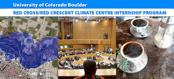
Red Cross/Red Crescent Climate Centre Internship Program
by Katie Chambers
Ethiopia, June 2017
Katie is a PhD student in Environmental Engineering with a focus on Engineering for Developing Communities. In Ethiopia, Katie will be developing flood inundation maps for communities downstream of hydroelectric dams. These maps will guide the development of Early Warning Early Action frameworks for the Ethiopian Red Cross Society and IFRC. Her environmental engineering research investigates the comparative vulnerabilities and resilience of different types of sanitation systems found in resource-limited communities, as well as the tradeoffs made when prioritizing resilience in system selection.
The sound of distant thunder echoes through my fifth-floor office in Ethiopia’s capital, Addis Ababa, and the city traffic has come to a standstill as rain saturates the ground below. The rainy season has just started in Ethiopia and will continue until August. Locals warn me to expect rain every day, but that “it is nothing compared to the rain in the United States”. With the rainy season comes hope of a break from the drought that has affected much of East Africa, but also the potential of floods impacting vulnerable communities. My project as an intern with the Red Cross Red Crescent Climate Centre this summer aims to address issues surrounding flooding and consists of two main objectives, to (1) develop inundation models to determine the extent of flooding on downstream communities and (2) develop a forecast-based contingency plan for the Red Cross to link the level of risk with the actions needed to protect communities from floods.
The project specifically looks at the Awash River and flooding downstream of Koka Dam, Ethiopia’s oldest hydroelectric dam, with the potential to expand the project to an additional dam currently in construction.
The first phase of the project consists of flood inundation mapping using HEC-GeoRAS, a software that combines HEC-RAS (a program that models water flow through natural and man-made channels) and ArcGIS (a program for the management, analysis, and display of geographic information).
The results are produced in a geospatial context, which allows users to determine the extent of flooding and predicted impacts to downstream communities. Controlled water releases from Koka Dam and precipitation during rainfall events both contribute to the water flow in the Awash River. Contribution of the dam release and the heavy predication to flooding need to be clarified. These different contributing factors have led to the proposal of three flood modeling scenarios for the Awash River: (1) water release exclusively from Koka Dam, (2) water exclusively from rainfall, and (3) both water release from Koka Dam and rainfall. Read more …

Notes from the Field in Ethiopia: Engineering Meets Humanitarian Action
Red Cross/Red Crescent Climate Centre Internship Program
by Katie Chambers
Ethiopia, June 2017
Katie is a PhD student in Environmental Engineering with a focus on Engineering for Developing Communities. In Ethiopia, Katie will be developing flood inundation maps for communities downstream of hydroelectric dams. These maps will guide the development of Early Warning Early Action frameworks for the Ethiopian Red Cross Society and IFRC. Her environmental engineering research investigates the comparative vulnerabilities and resilience of different types of sanitation systems found in resource-limited communities, as well as the tradeoffs made when prioritizing resilience in system selection.
The sound of distant thunder echoes through my fifth-floor office in Ethiopia’s capital, Addis Ababa, and the city traffic has come to a standstill as rain saturates the ground below. The rainy season has just started in Ethiopia and will continue until August. Locals warn me to expect rain every day, but that “it is nothing compared to the rain in the United States”. With the rainy season comes hope of a break from the drought that has affected much of East Africa, but also the potential of floods impacting vulnerable communities. My project as an intern with the Red Cross Red Crescent Climate Centre this summer aims to address issues surrounding flooding and consists of two main objectives, to (1) develop inundation models to determine the extent of flooding on downstream communities and (2) develop a forecast-based contingency plan for the Red Cross to link the level of risk with the actions needed to protect communities from floods.
The project specifically looks at the Awash River and flooding downstream of Koka Dam, Ethiopia’s oldest hydroelectric dam, with the potential to expand the project to an additional dam currently in construction.
The first phase of the project consists of flood inundation mapping using HEC-GeoRAS, a software that combines HEC-RAS (a program that models water flow through natural and man-made channels) and ArcGIS (a program for the management, analysis, and display of geographic information).
The results are produced in a geospatial context, which allows users to determine the extent of flooding and predicted impacts to downstream communities. Controlled water releases from Koka Dam and precipitation during rainfall events both contribute to the water flow in the Awash River. Contribution of the dam release and the heavy predication to flooding need to be clarified. These different contributing factors have led to the proposal of three flood modeling scenarios for the Awash River: (1) water release exclusively from Koka Dam, (2) water exclusively from rainfall, and (3) both water release from Koka Dam and rainfall. Read more …