Red Cross/Red Crescent Climate Centre Internship Program
by Sierra Gladfelter
Zambia, August 2016
In Zambia, Sierra is supporting the monitoring and evaluation component of the ‘City Learning Lab processes’ Zambia Red Cross Society program. This includes supporting the facilitation and documentation of the First Lusaka Learning Lab for the Future Resilience for African Cities and Lands (FRACTAL) project, including contribution to the development of a learning framework and establishing a learning baseline, researching background materials and preparing reading materials in collaboration with the FRACTAL team and documenting learning during the Learning Lab interactions and compiling a learning report.
Rural Zambian communities living on the floodplains of the Zambezi River are increasingly suffering from climate-induced disasters, with both floods and droughts alternatively striking and eroding their security. In Kazungula, an underdeveloped district located in the Southern Province upstream from Victoria Falls where the Zambia Red Cross Society (ZRCS) is currently supporting interventions, residents receive limited support in anticipating such disasters. While the Zambia Meteorological Department (ZMD) prepares and disseminates forecasts as part of its mandate to provide advisory services, the kind of data it is able to provide in terms of resolution and time scale is limited. Currently the ZMD distributes three types of forecasts including six-month seasonal forecasts with detailed information on how weather and climatic patterns like El Niño and La Niña will influence rainfall over the region, as well as 10-day and daily forecasts. This information, formulated at the national level and downscaled for each province, is disseminated by email to key stakeholders such as ZRCS Disaster management staff, agriculture extension officers, local government officials and individuals who formally request to be added to the department’s list. This is the same mechanism through which people would be warned in the event of an impending disaster.
In a country where much of the rural population lives isolated even from radio and cell phone service, however, the impact of electronically distributed forecasts and advisories provided by the ZMD is constrained. The data that makes it to the ground is primarily limited to seasonal forecasts which are printed on pamphlets and distributed annually by ZMD. On a short term basis, however, the burden of dissemination to local communities falls onto the shoulders of the nation’s agriculture extension officers employed by the Ministry of Agriculture and Livestock in each district. These individuals serve as the primary intermediaries between the ZMD and rural farmers in both providing and translating weather and climate information for local decision-making. While communities are primarily able to access this information at frequent village meetings, agriculture extension officers also have their own constraints and are often forced to provide services without reliable communication or transportation. For example, one agriculture extension officer whom I interviewed in Kazungula had not had a functional motorbike in a year and was only able to access the more remote communities by coordinating transport with other NGOs working in the area. These communication and logistical challenges mean that although ZMD regularly produces useful information to disseminate, even 10-day forecasts rarely reach rural Zambians while their content is still timely. Thus, the ZMD’s seasonal forecasts are currently the closest thing to a formal ‘early warning’ provided to communities in advance to floods and droughts.
“Knowing in advance that floods and droughts are predicted certainly does enable rural Zambians to take some precautionary measures. Most residents that I interviewed whose livelihoods depend on rain fed agriculture, described the utility of the ZMD’s seasonal forecasts for determining crop types and adjusting the timing of their planting. For example, if a drought is predicted farmers will plant drought-resistant varieties or traditional crops like sorghum that can handle a limited amount of water. In the case of flooding or excessive precipitation, people choose late maturing crop varieties. However, at the broad timescale of a seasonal forecast, the kind of actions that people can take without any actual lead time prior to a disaster, are severely limited.”
For this reason, Zambians living in communities in Kazungula depend equally, if not more, on traditional mechanisms for predicting floods and droughts.
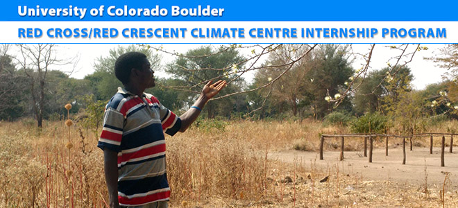
In interviews and focus groups with rural farmers living in the communities of Sikaunzwe, Kawewa, and Kasaya, community members described the most common indicators embedded in the landscape that they have historically relied on and continue to rely on to anticipate floods and droughts. By far the most common response I was given from nearly everyone I interviewed, was the significance of cobwebs suspended in the atmosphere as a portent for impending floods. Although the precise details of how these cobwebs emerge and the timing until a flood occurs remains unclear, informants consistently cited the presence of these nets of whitish silk that hover in the atmosphere as one of the surest signs of inundation. Similar phenomena of spiders escaping floodwaters on winds have been documented in places as diverse as Australia and Pakistan. Here in Zambia, when the webs are transported on northwest winds coming from upstream and settle onto trees in the bush, people can reliably expect floods in a short time. In fact, several people were so confident that every time they see these webs they will get flooded, that this sign alone is cause for relocation to the uplands. One informant who had lost his home and 39 animals in the devastating 2006 flood, said that he had seen the cobwebs prior to that event and so when he saw them again in 2008 took early action to prevent more loss. Sure enough, by February another devastating flood had struck the region. Read more …


Notes From the Field: Anticipating Disaster – Formal Climate Information vs. Traditional Ways of Knowing Floods and Droughts
Red Cross/Red Crescent Climate Centre Internship Program
by Sierra Gladfelter
Zambia, August 2016
In Zambia, Sierra is supporting the monitoring and evaluation component of the ‘City Learning Lab processes’ Zambia Red Cross Society program. This includes supporting the facilitation and documentation of the First Lusaka Learning Lab for the Future Resilience for African Cities and Lands (FRACTAL) project, including contribution to the development of a learning framework and establishing a learning baseline, researching background materials and preparing reading materials in collaboration with the FRACTAL team and documenting learning during the Learning Lab interactions and compiling a learning report.
Rural Zambian communities living on the floodplains of the Zambezi River are increasingly suffering from climate-induced disasters, with both floods and droughts alternatively striking and eroding their security. In Kazungula, an underdeveloped district located in the Southern Province upstream from Victoria Falls where the Zambia Red Cross Society (ZRCS) is currently supporting interventions, residents receive limited support in anticipating such disasters. While the Zambia Meteorological Department (ZMD) prepares and disseminates forecasts as part of its mandate to provide advisory services, the kind of data it is able to provide in terms of resolution and time scale is limited. Currently the ZMD distributes three types of forecasts including six-month seasonal forecasts with detailed information on how weather and climatic patterns like El Niño and La Niña will influence rainfall over the region, as well as 10-day and daily forecasts. This information, formulated at the national level and downscaled for each province, is disseminated by email to key stakeholders such as ZRCS Disaster management staff, agriculture extension officers, local government officials and individuals who formally request to be added to the department’s list. This is the same mechanism through which people would be warned in the event of an impending disaster.
In a country where much of the rural population lives isolated even from radio and cell phone service, however, the impact of electronically distributed forecasts and advisories provided by the ZMD is constrained. The data that makes it to the ground is primarily limited to seasonal forecasts which are printed on pamphlets and distributed annually by ZMD. On a short term basis, however, the burden of dissemination to local communities falls onto the shoulders of the nation’s agriculture extension officers employed by the Ministry of Agriculture and Livestock in each district. These individuals serve as the primary intermediaries between the ZMD and rural farmers in both providing and translating weather and climate information for local decision-making. While communities are primarily able to access this information at frequent village meetings, agriculture extension officers also have their own constraints and are often forced to provide services without reliable communication or transportation. For example, one agriculture extension officer whom I interviewed in Kazungula had not had a functional motorbike in a year and was only able to access the more remote communities by coordinating transport with other NGOs working in the area. These communication and logistical challenges mean that although ZMD regularly produces useful information to disseminate, even 10-day forecasts rarely reach rural Zambians while their content is still timely. Thus, the ZMD’s seasonal forecasts are currently the closest thing to a formal ‘early warning’ provided to communities in advance to floods and droughts.
“Knowing in advance that floods and droughts are predicted certainly does enable rural Zambians to take some precautionary measures. Most residents that I interviewed whose livelihoods depend on rain fed agriculture, described the utility of the ZMD’s seasonal forecasts for determining crop types and adjusting the timing of their planting. For example, if a drought is predicted farmers will plant drought-resistant varieties or traditional crops like sorghum that can handle a limited amount of water. In the case of flooding or excessive precipitation, people choose late maturing crop varieties. However, at the broad timescale of a seasonal forecast, the kind of actions that people can take without any actual lead time prior to a disaster, are severely limited.”
For this reason, Zambians living in communities in Kazungula depend equally, if not more, on traditional mechanisms for predicting floods and droughts.
In interviews and focus groups with rural farmers living in the communities of Sikaunzwe, Kawewa, and Kasaya, community members described the most common indicators embedded in the landscape that they have historically relied on and continue to rely on to anticipate floods and droughts. By far the most common response I was given from nearly everyone I interviewed, was the significance of cobwebs suspended in the atmosphere as a portent for impending floods. Although the precise details of how these cobwebs emerge and the timing until a flood occurs remains unclear, informants consistently cited the presence of these nets of whitish silk that hover in the atmosphere as one of the surest signs of inundation. Similar phenomena of spiders escaping floodwaters on winds have been documented in places as diverse as Australia and Pakistan. Here in Zambia, when the webs are transported on northwest winds coming from upstream and settle onto trees in the bush, people can reliably expect floods in a short time. In fact, several people were so confident that every time they see these webs they will get flooded, that this sign alone is cause for relocation to the uplands. One informant who had lost his home and 39 animals in the devastating 2006 flood, said that he had seen the cobwebs prior to that event and so when he saw them again in 2008 took early action to prevent more loss. Sure enough, by February another devastating flood had struck the region. Read more …