Quartz
by Tim McDonnell & Daniel Wolfe
Thanks to climate change, destructive flooding caused by hurricanes is on the rise. But so is a less dramatic, if still pernicious, type of flooding. So-called sunny-day floods, which occur mostly in the fall when seasonal ocean tides are at their peak, are occurring more often as sea levels rise.
But scientists and urban planners often struggle to predict the impacts of these high-tide floods along the Atlantic and Gulf coasts. The mere fact that a town’s local tide gauge registers a flood isn’t particularly helpful for, say, school administrators deciding whether to cancel class, or cops deciding which roads to close, or insurance adjusters looking to raise premiums in vulnerable areas.
So some researchers are looking for clues in a new place: Twitter.
There’s good reason to search for more powerful indicators of flood impacts: Sunny-day floods disrupt traffic, threaten infrastructure, and drain local economies. A study in Science last year found that high-tide flooding cost businesses in downtown Annapolis, MD, more than $100,000 in lost revenue in 2017.
Currently, the main sources of data on sunny-day floods are tide gauges, which are often few and far between. They also don’t paint a very detailed picture of how water levels will actually affect a community, said Katherine Mach, an environmental scientist at the University of Miami who led the Annapolis study.
“Most of what we know about coastal flooding is how it affects people through major disasters. We know less about nuisance floods, recurring, short-duration floods,” she said. So, “understanding how high-tide floods directly impact people is a really challenging issue that has been intractable so far.”
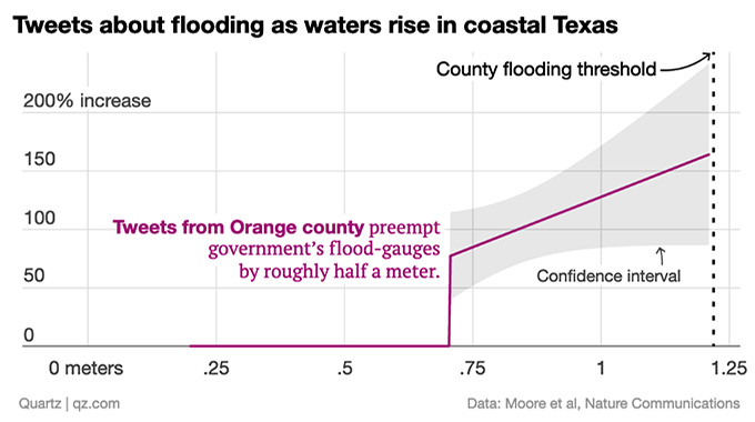
A new paper in Nature Communications takes a stab at a different approach: Monitoring flooding through peoples’ exasperated tweets. The analysis, which combed through half a million tweets geotagged in more than 200 counties along the East and Gulf coasts from 2014-2016, found that high-tide floods may be even more widespread than a report from NOAA had suggested. In 22 counties—including those of Miami, New York City, and Boston—the study documented a spike in apparently flood-related tweets at tide levels up to half a meter lower than what the gauge recorded as a flood.
The study looked for changes in the volume of tweets containing at least one of 45 flood-related keywords—including tide, inundate, sandbag, drenched, storm drain, and rising waters—and matched those with water levels as reported by the county tide gauge.
Unsurprisingly, in most cases, flood-related tweets ramped up at about the same water level that the tide gauge registered as a flood. But in those 22 counties, the tweets picked up much earlier, suggesting that in some of America’s most populous coastal cities, sea level rise is already more of a recurring headache than official records would suggest.
This approach “integrates the physical exposure to flooding [i.e., water level] with the actual disruptions people associate with that,” said lead author Frances Moore, an environmental science and policy professor at the University of California, Davis. “So in some ways it’s a more natural way to measure the consequences of flooding.”
The study is a followup to another Moore led last year, which used Twitter data to track reactions to extreme temperature events. In that study, Moore found that temperature-related tweets tend to spike during exceptionally hot or cold weather, but drop off in locations that have experienced weather extremes for several years in a row, suggesting that people can get used to a shifting baseline quickly.
The new flooding study is much smaller (the temperature study included 60 million tweets). And tweets have plenty of pitfalls as a source of data on climate change impacts.
Moore reports that on closer inspection, more than half of the tweets tagged as flood-related were false positives, meaning they included one of the keywords but weren’t really about flooding (although because that rate didn’t seem to change during high tides, Moore says it doesn’t affect the study’s conclusions). The demographics of Twitter users are also not representative of society at large. It can be difficult to verify that any particular tweet isn’t either misinformed or intentionally misleading. And only around one percent of all tweets are geotagged, according to Ali Mostafavi, an urban resilience researcher at Texas A&M University who has separately tried using social media to examine climate change impacts.AP PHOTO/BRIAN WITTEPolice closed Dock Street in downtown Annapolis in Oct. 2017, after winds at high tide caused flooding on two streets in Maryland’s capital city.
Still, Mostafavi said, there’s a growing appetite among climate researchers to use social media data—particularly data from Twitter, which is more easily accessible to researchers than Facebook or Instagram—to fill in information gaps in the wake of natural disasters. So far, that effort includes giving early warnings of emerging wildfires and analyzing photos attached to tweets to identify where emergency services might be needed.
Other novel data sources, including satellite imagery and drone footage—the Annapolis study even relied on parking meter records—can also help supplement traditional disaster data.
“As long as we work in a complementary way with scientific sources, like tide gauges, these are great developments,” said Max Boykoff, director of the Center for Science and Technology Policy Research at the University of Colorado-Boulder.
“The more data we can get at a greater resolution, will really help us better understand where people are at risk, where they’re vulnerable,” he said.

