8 Aug 2014, by Matt Shupe [76N, 176E]:
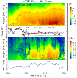
OK, maybe that title is a bit extreme, but this recent event really does mean the end for much of the ice in this region. Our measurements over the past days have documented this amazing blob of warm, moist air overhead that advected into the East Siberian Sea from somewhere to the south. I mentioned this already a few days ago: +18C at 400m overhead when the surface temperature was near 0C (check out the data plot). But that heat was not alone. Importantly the air mass also contained a lot of moisture, and as it cooled this moisture supported clouds and fogs. Warm air by itself may not have done much, not even warm-moist air. But when the clouds get added, that is when the radiation balance really starts to change. The clouds block some sunlight, which cools the surface. However, these same clouds also trap thermal radiation and are the efficient means for transporting that heat aloft down towards the surface. It turns out that during this event, and often in the Arctic, the thermal trapping effect of clouds is strongest such that they actually warm the surface. (Well, it’s a bit more complicated than that but no need to jump into too many details!). This blob of warm-moist-cloudy air has made its presence known in the region. Sea-ice maps have shown a dramatic thinning of the ice pack in the East Siberian Sea over the past few days, and we¹ve experienced this first hand as the melt ponds get larger and darker, and the icebreaking gets easier.

