28 July 2014, by Paul Johnston [76.61 N, 147 E]:
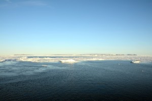
We are currently within sight of Bennett Island. This is the first land we have seen since leaving Norway on 5 July. Bennett is a piece of volcanic rock (about 60 sq. miles) with an ice cap on top. In the photo, if you look closely at the top of the island, you can see the ice cap, remains of a glacier from the last ice age. When this picture was taken, we were sitting in an open area of water. We will go through the ice you see in the background, as we head east (to the right) of the island. We are sailing around the island, taking sediment samples and monitoring the ocean. After about a week in open water, we are back in an area with ice.
Bennett Island has some unexplained phenomenon associated with it. It generates a plume that is visible from satellite. I think it is a cloud, but others have suggested it is a methane cloud (which I don’t believe). It is interesting to see land for a little while. We have had about 24 hours of nearly continuous sun and blue sky. It is getting foggy again, and we will soon be back underneath clouds.
We had a mid-cruise party last Thursday evening, celebrating the mid-point of the cruise. It wasn’t really the mid-point, but it was a good celebration. It is hard to establish where or when the midpoint is, but it is certainly close. Life on the ship has quieted down, with about half of the scientists working shifts. This means that there is always someone up and someone sleeping.
We are approaching station 44. Usually at each station we do a CTD cast, which means sending a probe to near the bottom to measure the salinity and temperature profile, as well as collect water samples from different depths (there are 24 sampling cylinders in the probe). Then after the CTD, we do a sediment core probe. The sediment coring usually brings 10-20 cm of sediment from the bottom of the ocean. The CTD drops off the bow of the ship, and the coring is done from the aft. Because of depth issues, we can only do one probe at a time. Currently, the water is only 40-50 m deep, but we have been in 3000 m water. Sometimes a larger core, using different equipment is used that gets up to 6 m long cores from the bottom. There are also other equipment that are not always used, including putting in a submersible pump on a long hose to get large volume water samples from well below the surface. Many of the scientists are involved in obtaining the samples and running the equipment. Then many more are involved in analyzing or preserving the samples.
The equipment we are working with is running well. I am working on processing the data, trying to remove sea-clutter contamination from the atmospheric echoes on the 449 MHz radar. We have rearranged some of our equipment and boxes. I am now working mainly in a sea-container about 12′ from the radars (there is one sea-container between). This is equipped as a lab/workspace and has a window that looks out the front of the ship. I have an network connection and can keep up on the status of the ship.
There are plenty of social activities on board. Meal times are good times for discussion. Tonight I am going to see a movie, if the equipment works. I think it is a modern remake of Kon-Tiki.

