Yesterday, the 20th of July, was the concluding day of Flight Week. The total number of profiled flights was 1,162, all done in just 4 days of field work! Final operations included a calibration of instruments against the Mobile UAS Research Collaboratory (MURC) CU Boulder had brought. With the 60 foot tower gathering similar measurements as the drones and planes, a data comparison can easily be made either by flying in circles (for rigid-wing systems) or loitering close to the sensors (for drones).
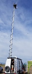
MURC making last day calibrations with a small drone on the right.
Moreover, CU Boudler students were already on the process of visualizing data, such as the flight paths of their rigid-wing UAS Twister and Mistral. One student had plotted a bird’s-eye-view of the flight patterns, displaying a consistent orbit around the tower. For most of the vehicle’s flight time, an autonomous or autonomous with pilot-capabilities system is directing the plane. This makes for a precise dataset from any recorded profiles. On the hazy figure shown below, the path of the airplane is shown along with windspeed measurements presented as color change.
Having had the wonderful opportunity to learn about the different methods of data collection, the in depth analysis of multiple atmospheric properties and phenomenons, and the multiple part of scientific field work, I can say I am privileged to be a part of the NOAA and atmospheric science community.
Thanks to everyone for wonderful moments!
Signing off, Kevin Olivas.