A guest post from Dr. Steve Ackley, University of Texas San Antonio:
Part of the sea ice program will be “underway” sea ice measurements conducted by the group from the University of Texas at San Antonio (Steve Ackley, Blake Weissling and Bob Ziegenhals) . While prior sea ice measurements of ice thickness have had to be done either on the ice surface or from a low flying aircraft, we have constructed a new Sea Ice Measurement System (SIMS) on a frame that will be slung over the side of the vessel while it is underway. The instruments mounted on the frame are an electromagnetic induction (EMI) device, a snow radar, a laser altimeter and an infrared camera.
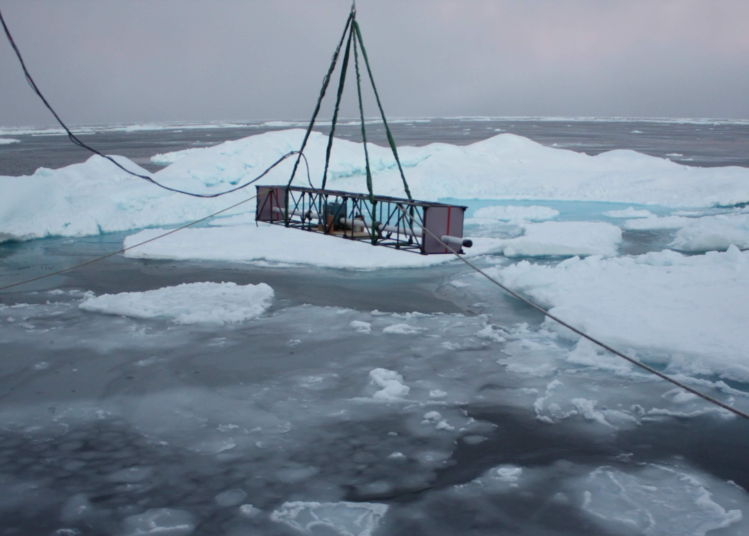
Inside the metal frame: An electromagnetic induction (EMI) device, a snow radar, a laser altimeter and an infrared camera, for measuring sea ice thickness while the ship is underway.
The EMI will measure total snow and ice thickness, when corrected for the height above the surface by the altimeter. The snow radar measures snow depth, so ice thickness alone can be obtained by subtracting the snow radar’s snow depth from the EMI’s total snow and ice thickness. The infrared camera will measure the surface temperature of the surface and help differentiate a snow or ice surface from an open sea surface. Mounted separately on an upper deck are an automatic camera and a scanning lidar looking out in the path traveled by the SIMS. These two devices will be used to obtain estimates of the percentages of ice and open water in a camera scene (the ice concentration) and the surface elevation or ice roughness from the lidar scanner.
The first application of these measurements are to assist the wave-ice modelers, as wave propagation into the ice edge region depends on knowing the ice thickness, the ice concentration, and the floe sizes encountered as a function of distance from the ice edge. As waves can propagate from a few to tens of kilometers from the open ocean into the ice, the SIMS, camera and lidar, by being vessel-mounted, will give a first opportunity to obtain all these parameters over those distances into the ice pack. Wave measurements are being made simultaneously by other groups on board. The second application is to better use airborne and satellite remote sensing by providing “ground truth” of the estimates of ice thickness, surface elevation and ice concentration obtained by those sensors.