We completed our first successful Aerosonde UAV science flights to Terra Nova Bay last night and we are all really happy to finally be getting the data we’ve come here for.
Nick, Cam, Peter, and I went out to the Pegasus ice runway yesterday afternoon to launch two Aerosondes for the overnight mission. You can see a video of the first launch here.
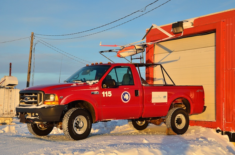
The second Aerosonde loaded on the launch truck and ready for take-off.
The second Aerosonde just as it lifts off from the launch truck.
The launches went as smoothly as could be expected. It was cold at the runway with a temperature of -25 deg F. More than the temperature our main concern was the wind which was blowing at about 12 mph. The concern with this is that the wind was a crosswind on the runway and typically we try not to launch the Aerosondes with more than about an 8 mph crosswind. Despite the stronger winds than we’d like to have for a take-off Cam did a great job with both takeoffs.
Back in McMurdo Paul and Shelley guided the Aerosondes to Terra Nova Bay. En route to Terra Nova Bay the weather was very cooperative with generally light flight level winds and very little moisture or clouds which eliminated our concern of an icing related accident.
Upon reaching Terra Nova Bay Shelley, Paul and I directed the Aerosondes to observe the features of most interest for our research. We dropped down to just 300 feet above the surface of the ocean and commenced a series of low level flights to measure the winds, temperature, and moisture over the sea ice and open water in the bay. The area of open water was our main interest and is known as a polynya. We are interested in studying the atmosphere over the polynya because during the Antarctic winter cold air from the interior of the continent blows out over Terra Nova Bay. When sea ice is present the sea ice acts like a blanket over the ocean and inhibits heat and moisture from being removed from the ocean by the overlying cold, dry air. If the winds blowing off of the continent are strong enough the sea ice near the coast gets blown out to sea leaving an area of open water right along the coast. This area of open water is the polynya we are studying.
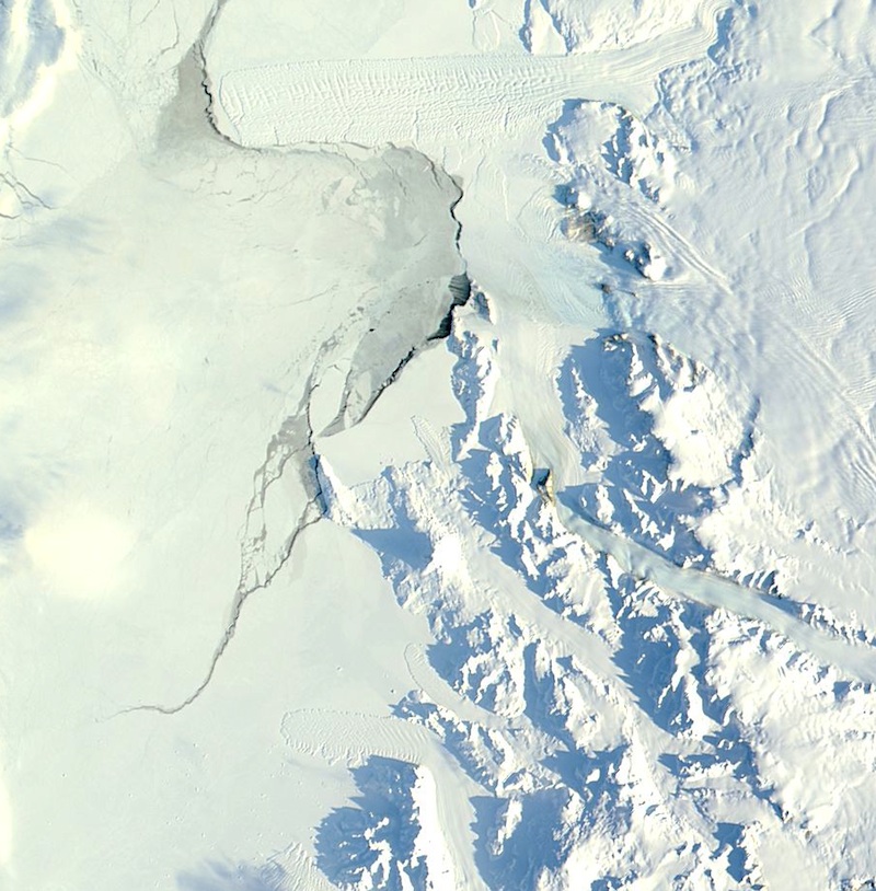
You can see the polynya in this is satellite image of Terra Nova Bay taken just before yesterday’s flight. The right half of this image shows the Antarctic continent with the Transantarctic Mountains along the coast. You can see several glacial valleys passing through the mountains. The cold air from the interior of the continent drains through these valleys and creates the strong winds we observed in Terra Nova Bay. The slightly less bright white on the left side of the image is sea ice (and some clouds) covering the Ross Sea. Right at the coast you can see a dark area in the center of the image. This is the polynya we are studying. Yesterday the polynya was relatively narrow – just about 3 miles across but it can be ten times bigger than that under the right conditions.
When the sea ice is absent, as is the case in the polynya, large amount of heat and moisture can be extracted from the ocean. By removing this heat and moisture the ocean water becomes colder and saltier and as a result becomes more dense. This dense ocean water can then sink to the bottom of the ocean and feeds into a global ocean circulation known as the thermohaline circulation. The thermohaline circulation is driven by temperature (thermo) and salinity (haline) differences and is responsible for moving heat from the tropics to the polar regions. This ocean circulation is a critical part of the Earth’s climate system. The part of this that most of you are probably familiar with is the Gulf Stream in the Atlantic Ocean. The Gulf Stream takes heat from the Gulf of Mexico and moves it into the Arctic Ocean, and in the process keeps places like Scandinavia much warmer than they would be otherwise. The cold, salty water formed in the Terra Nova Bay polynya is a part of this global ocean circulation so we would like to better understand the processes that control how cold and salty this water becomes and the interaction between the atmosphere and ocean is the key for this process.
As was expected the winds in Terra Nova Bay were strong – mainly blowing 50 to 60 mph. In the span of just a few minutes of flying time we went from light winds of less than 10 mph to winds greater than 50 mph. It was like the Aerosonde flew into a wall of wind. This was a feature of the winds at Terra Nova Bay that we had observed during our UAV flights in 2009.
In addition to mapping the winds at low levels we also had one of the Aerosondes complete a series of spiral ascents and descents through the lowest 5000 feet of the atmosphere to allow us to observe how the atmosphere changed with height over the polynya. These vertical profiles of the atmospheric state will allow us to estimate how much heat and moisture is being removed from the ocean and deposited in the atmosphere and will also allow us to study the dynamics of the strong winds that occur in Terra Nova Bay.
The other Aerosonde not only mapped the low level winds in Terra Nova Bay but also carried a laser altimeter that allows us to measure the height of the waves and the thickness of sea ice in Terra Nova Bay. The wave height is important because it tells us how strongly the winds are influencing the circulation and mixing in the ocean. The sea ice thickness is important because it lets us measure how much sea ice is present on the edges of the polynya. We get nearly all of the data back from the Aerosondes in real time but the laser altimeter data needs to be post-processed by colleagues back at the University of Colorado before we can use it so we haven’t seen this data yet.
After spending more than 6 hours flying around Terra Nova Bay we started the long flight back to the Pegasus ice runway. The flight back takes about 4 hours and as with the flight up to Terra Nova Bay we had good weather with generally light winds and very little moisture or cloud cover to worry about. Both planes landed safely this morning after completing their more than 14 hour long missions.
We’ll be launching two more Aerosondes tonight and hopefully two more tomorrow night. This will let us see how the Terra Nova Bay polynya and overlying atmosphere changes over time.
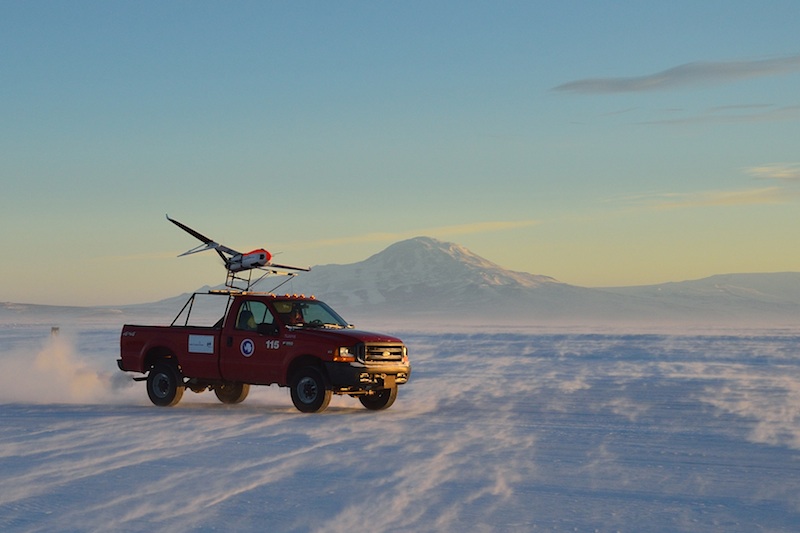
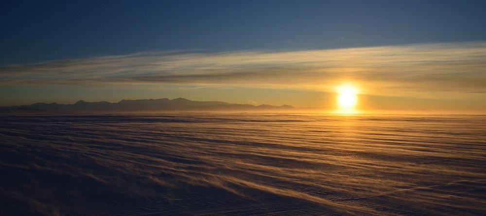
I’ll end with a photo of the sunset yesterday, just after our second Aerosonde launch. As you can see the crosswind we had was creating a fair bit of drifting snow on the surface.
How fast do you need to go to launch the aerosonde?
How fast does it fly once airborne?
The Aerosondes need to be going about 60 mph for the launch. Their cruising speed is about 55 mph but can do 70 mph when needed. We can get into winds that are too strong for us to make headway so we have to plan our flight path carefully to make sure we can get back safely.
We are so happy to hear about your success! Your photography of the Antarctic is amazing. I loved the night pics from your last post. Best wishes for continued success!
Thanks Tiffany. I hope all is well with you, Justin, and Charlotte.
do you have a spec sheets on the different aerosondes?
The Aerosondes we are using for this project have a 12 foot wingspan and weigh about 35 pounds on take off. These are just a bit larger than the ones we flew in 2009. The slightly larger planes can carry a bit more fuel so we can fly for up to 19 hours at a time.
Can you please tell me how icing is affecting your flights and if you are receiving rain, how hardy is the Aerosonde? How much can it experience before you have to turn back? Thanks.
-J
Icing is definitely a concern for our UAVs and we had one crash due to icing on the pitot tube
that measures air speed. The icing occurs in clouds of supercooled water. Rain is not a concern
here so the icing is all in the form of small cloud droplets. Given the small size of the Aerosonde
we turn away from any icing conditions as soon as we see that they are occurring.