by Jeff Lukas, Western Water Assessment, CIRES
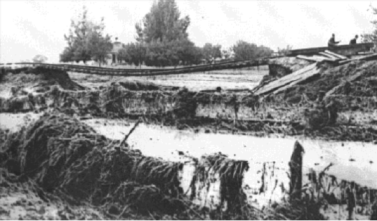
In early September, a favorable atmospheric circulation pattern sent copious subtropical moisture streaming towards the Front Range. As that pattern persisted for three days, areas of heavy rainfall fired up repeatedly over the Front Range foothills, leading to 24-hour amounts over 5 inches in some locations and 3-day totals over 8 inches. The cloudbursts caused flooding in nearly every drainage from Colorado Springs to the Wyoming border, including Bear Creek, Coal Creek, South Boulder Creek, St. Vrain Creek, the Big Thompson River, and the Cache la Poudre River.
Bear Creek burst its banks and badly damaged downtown Morrison. Rampaging South Boulder Creek carried off parts of the Eldorado Springs Resort and undermined streamside houses. In Longmont, the northern residential district was flooded. And in Fort Collins, much of the campus was inundated. At least seven people were killed in the flooding. Never before had so much flood damage occurred over such a broad north-south swath of the Front Range.
While this sounds a lot like what happened 10 days ago, the extraordinary floods described above occurred from September 1st-3rd, 1938, 75 years ago this month. Afterwards, that disaster faded into history, but as the more recent floods subsided, it has reemerged to clearly answer the questions, “Has anything like this ever happened before?” and “Have we ever had severe flooding in September?”
While the total precipitation amounts in the shorter-duration 1938 event were not as high as in 2013’s, the flooding was of a similar magnitude across the affected area, perhaps because there was more convective activity (thunderstorms) in 1938, leading to higher peak rainfall intensities than in 2013.
If we query the NOAA 20th-century reanalysis dataset—which blends historic surface and upper observations in a numerical weather model to create detailed and consistent images of past atmospheric circulation—we can do a quick comparison of the setup for the 1938 event with that for 2013. What we find is that the patterns were remarkably similar: a low pressure area to the west that drew moisture from the south and east, and blocking highs that kept the moisture flow pinned in place for several days.
While research is ongoing at CIRES to investigate how the 2013 flood may have been influenced by human-caused climate change, the 1938 flood tells us that the climate system was capable of producing that type of flood event—in September, no less—under more “natural” atmospheric conditions.
Thanks to Joe Barsugli and Klaus Wolter, CIRES and NOAA ESRL PSD.