This is Gijs de Boer again providing a perspective on Sunday’s flights. This morning I found myself in a strange position. Despite having put a ton of time and work into flight week, I had no place to formally be. Unlike in previous campaigns, where I’ve been directly involved with the actual aircraft operations, this week all of the aircraft are being operated by other groups. Even the DataHawks, with which I’ve spent a lot of time in the Arctic, are being flown by Dale Lawrence and Abhiram Doddi of CU. Beyond this, the students that accompanied me down to the San Luis Valley, including Kevin, were all occupied with other activities such as launching radiosondes and completing additional calibration flights. So, this morning I set off to do a “Tour de SLV” (unfortunately not on my bike), hopping from operating site to operating site.

The University of Kentucky prepares for their next flight.
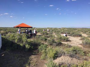
The first site I visited was a University of Kentucky site, on the edge of a farm field. One of the major challenges associated with the development and execution of this campaign has been to secure permission to fly from someone’s land. While roadways are public and sometimes some of the land around them is as well, in an ideal situation teams have had a chance to speak directly with the owners of the land around their operation. In this case, Kentucky had asked the landowners whether they could set up their tents and aircraft operations on an unused farm site and they said that it would be no problem. In general, people in the San Luis Valley have been friendly and welcoming and that alone makes the operation much easier.
From this site, I went on to the east toward the Great Sand Dunes National Park, to a site where Oklahoma State was setting up. As an aside, the National Park Service keeps very strict control over the use of drones over their land. Of our group, Nebraska worked with NPS to secure permission to operate from the Great Sand Dunes Park, but Oklahoma State was able to set up on the boundary. It is amazing to me how much of a transition there is between different parts of the valley. While the area around Leach Airport is surrounded by agricultural fields, the eastern slopes along the Sangre de Cristo mountains are dry and desert like. In fact, I saw a large snake (I believe a rattle snake), which had unfortunately been run-over along the road on the way there.
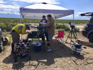
Oklahoma State sets up their equipment in the dry shrub land of the eastern San Luis Valley.
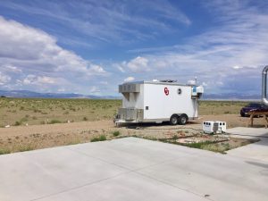
The University of Oklahoma CLAMPS trailer, filled with instrumentation, watches the skies over Moffat.
After this, I visited another Kentucky site, a site covered by the Finnish Meteorological Institute and Kansas State, and finally a site at the Moffat School where the University of Oklahoma has both aircraft and ground based instrumentation. Again along the lines of community support, Moffat was kind enough to allow us to not only base at their school, but also tap into power and internet!
After lunch (and pie!), I did a bit of site scouting for one of the other missions and headed west toward Saguache. At this point there was quite a bit of convective storm activity (exactly what we were working to study!), including some lightning. Because of this, the OU team that was operating at Saguache Airport had already packed up (wisely) and it was time to head back to Alamosa for today’s weather briefing.
All in all, over 100 research flights and seven radiosonde launches in a single day! In addition to the ground based measurements and model simulations, today’s measurements represent a fantastic start to the LAPSE-RATE campaign!
Kansas State and the Finnish Meteorological Institute prepare for operation of their three aircraft.