20 July 2014, by Matt Shupe [77N, 130E]:
It might be nice for you to see where we are and where we’ve been, so I’ve put together a little map. On yearday 186 (5 July) at about 5pm, our path leaves from Tromso, Norway. We took a number of hours to head out through the fjords towards the open ocean. This transit was pretty entertaining. Few clouds with lots of sun (a rarity on this voyage so far!) made for vibrant colors. Snowy mountain peaks descending down to Arctic waters. Every so often we would encounter a little village, typically in a small valley leading down to the water. And there were even a few singular houses, out in their own space away from the rest of civilization. Only access as far as I could tell is by boat or helicopter. People living in their own paradise looking out into the Arctic (ok, perhaps not all would call this paradise!).
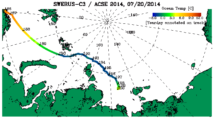
Our voyage so far
Once out in the open water, we made a straight path right across the Barents Sea. On the map I’ve plotted our course using a color scale that shows the ocean temperature at about 8m below the surface. As we move north, the ocean gets colder. Our entry into the ice just south of Franz Joseph Land (at the day 190 marker) is demarcated by ocean temperatures that consistently dropped down below -1.5C. This is approaching the freezing point of ocean water; in principle, the bottom of sea ice and upper ocean just below the ice are in equilibrium at the freezing point. For a week we cruised through the ice pack with varying thicknesses and concentrations of ice. Many amazing scenes, solid blue ice, all kinds of rotten ice, melt ponds, ice bergs, interesting cracks, ice algae, polar bears, seals, birds, fogs. The going got fairly tough around days 193-195 as the ice was thick and under a lot of pressure. At times this required backing the ship up for another charge, or even on occasion fully turning around to find another route. Since about day 197 we have again exited the ice, now in the Laptev Sea, and the local scenery is much less entertaining! Gray open water in all directions. Clouds being the only variability, but most of the time we are cloaked in fog anyway. This morning we even had some snow for a while. Today we’ve also faced slightly stronger winds and larger waves. Oden shakes and shudders when heading through them (challenging my typing here!). The last days have been a series of stations, dropping the anchor to sample along the ocean shelf region. We’ll spend a number of days in this region, then have a few more potential stations further to the east as we make our way over the next month towards Barrow, Alaska (the little point of land sticking out under the temperature label on the far right side of the map). More than half way there in distance, but not yet in time.