The last few weeks have been spent preparing to deploy to Alaska. No matter how many times you go over the packing list, or how thoroughly you review your itinerary, there is always the potential for something unexpected to happen. Having said that, I have to admit that I was not anticipating that something would go wrong as early in the trip as it did…
My trip started as most of my trips do — with a walk to the Boulder downtown transit center to catch the RTD SkyRide AB bus to Denver International Airport. I’ve taken this bus many, many times over the last three years, and consider myself to have a pretty good grasp on how to ride that route — I know that the best seats for legroom are generally about 1/4 of the way towards the back on the right hand side… I know that traffic on I-270 can result in substantial delays at certain times of the day… I know to have the $2.50 charged to Eco-Pass holders ready to go when boarding. However, none of that helps when you misread the schedule and miss your bus by 10 minutes. Oops… After calling a taxi company and Greenride and determining that those were not really going to help me get to the airport in time, I walked back home, rounded up my family and we all drove to the airport together. Needless to say, this is not really what they wanted to be doing…
Unfortunately, after that little speedbump, the journey did not get easier. I was supposed to fly to Chicago, and then onwards to Anchorage. Due to standard issue flight delays and a lengthy wait at the gate in Chicago due to concern about a passenger on our flight having Ebola (think many, many emergency vehicles and hazmat suits…), I missed my connection to Anchorage. This ultimately resulted in a non-planned overnight in Seattle and an early flight this morning. When I arrived in Anchorage I met up with CU postdoctoral researcher Jack Elston. Jack is an experienced unmanned aircraft pilot and he will act as pilot in command for our research flights at Oliktok Point (more on this in a minute). Together, we’ve spent the last few weeks getting practice flights under our belts, learning about the DataHawk aircraft that we’ll be operating, and reviewing our operations plan. Later this afternoon, we’ll continue our journey up to Deadhorse, Alaska, the nearest airfield serviced by commercial flights. After meeting up with an additional researcher from Penn State, we will drive the last leg from Deadhorse to Oliktok Point.
By now you may be wondering where exactly Oliktok Point is, and perhaps more importantly, why we want to go up there. Oliktok Point is located in north central Alaska (70.51 N, 149.86 W – see map below), along the Beaufort Sea. Historically, this site has been home to a US Air Force Long Range Radar Station, and recent years have seen a substantial increase in natural resource extraction. Over the next several years, the United States Deparment of Energy (DOE) Atmospheric Radiation Measurement (ARM) program will be operating a facility to make measurements here to help document if and/or how the Arctic atmosphere may be evolving, and help scientists better understand processes controlling Arctic clouds, aerosols and more. In support of this deployment, the DOE ARM program is funding our CIRES team to operate a small, lightweight unmanned aircraft over the next two weeks as part of Coordinated Observations of the Arctic Lower Atmosphere (COALA) operations. Our main objective is to make measurements necessary for estimating turbulent surface fluxes of heat and moisture between the surface of the Earth and the lower atmosphere. Measuring these fluxes and characterizing our ability to capture the necessary information from unmanned aircraft is critical in several ways, including for understanding the energy balance at the surface of the earth, and in evaluation of the impact on expanding open ocean surfaces on the formation or dissipation of clouds. If we are lucky with our timing, we will be able to measure temperature, humidity and winds in the near-surface environment during the transition from open ocean to sea ice cover. These transitions have proven extremely difficult to characterize because of challenges associated with deploying instrumentation on thin, unstable ice surfaces, but understanding them is vital in studying an Arctic system that features significant increases in the amount of thin, first-year sea ice.
Now, it should be noted that obtaining a certificate of authorization (COA) from the Federal Aviation Administration (FAA) for operation of unmanned aircraft for commercial reasons (basically anything associated with someone’s work) can be challenging in the United States due to existing regulations. That’s not to say that the regulations are pointless or unwarranted, but they do limit the amount of fundamental research that can be done using unmanned aircraft. These challenges are another part of why we are headed to Oliktok Point, and why the DOE has decided to develop a facility there. With foresight, the DOE has worked hard to maintain a small (4 nautical mile diameter) area of restricted airspace over Oliktok Point. This restricted airspace, when activated, allows the DOE to manage airborne activities occurring within that space, allowing for expanded use of manned and unmanned aircraft, as well as various balloon systems, in making atmospheric measurements.
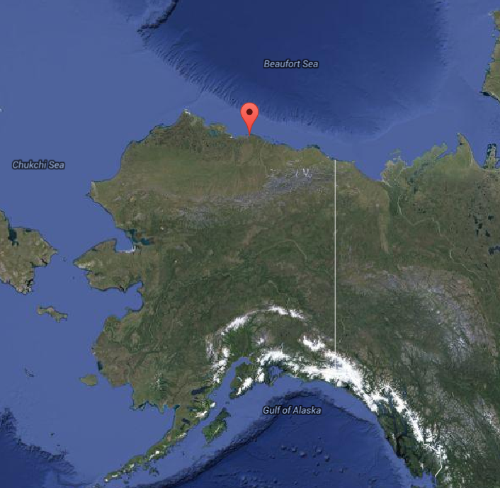
Oliktok Point, indicated by the red symbol on the map, represents an interface between the tundra of the North Slope of Alaska, and the Beaufort Sea and Arctic Ocean.
In conclusion, I’m very excited about this campaign. I’m certain that there will be challenges to overcome, but in the end I’m optimistic that we will end up with a unique and interesting dataset to help us better understand how the surface and atmosphere interact with one another at high latitudes. Over the next two weeks, please check back for updates on our activities as well as on life on the North Slope.